
Most surfers glance at the star rating, grab their board and hope for the best. But surf conditions are way more nuanced than star, number or colour ratings.
If you’ve ever rocked up to find mush instead of magic, this guide’s for you!
We’ll explain what a surf forecast actually shows, how to read it properly and why learning this skill will help you score better waves more often.
No more frustration. No more missed sessions. And definitely no more hearing, “You should’ve been here yesterday!”.
Let’s nerd out on surf forecasting.
What is a surf forecast?
A surf forecast is a prediction of wave, wind, tide and overall surfing conditions that helps you decide when and where to paddle out.
It draws from ocean buoys, satellites and weather models to provide data on swell, winds and tides—key factors that shape surfable waves.
Surf forecasts differ from surf reports, which describe current surf conditions in real time. Many surfers check both before heading to the beach.
Tools like Surfline, Windy and Windguru (header image courtesy of Windguru) give you a glance at the coming hours or days, helping you plan sessions at reef breaks, point breaks or beach breaks. These platforms include surf reports, live cams and tide charts, offering a quick yet powerful view of upcoming conditions across the world’s coastlines.
Where did surf forecasting start?
- Before the digital age, surfers relied on weather charts, buoy readings and word of mouth
- Forecasting meant decoding swell maps printed on paper or received by fax from sailors... often after hours of waiting for satellite info!
- In the 1950s, oceanographer Walter Munk helped develop the first swell prediction methods
- Wave energy modelilng began with naval science, translating into early surf forecasts as surfing grew
- Sean Collins, founder of Surfline, built custom models to predict swell heights and breaking waves long before apps existed
- Surfline launched as a call-in report system in the 1980s, then became a website in the 1990s with cams and forecasts
- By the 2000s, surfers everywhere could access high-res wave models and surf reports with just a few clicks or taps
- Nowadays there are multiple surf forecasting sites around the world, with everything from primary swell direction to distance between set waves (period) and even surf cams that allow you to check surf spots remotely
The key elements of a forecast
Reading a surf forecast means more than just checking a star or colour rating.
While no doubt helpful when you're just starting out, the best sessions are often had when you read between the lines, so to speak.
You need to understand the forces shaping the ocean’s movement. Each factor below plays a key role in determining when and where you’ll find clean, fun surf... or frustratingly flat or choppy seas.
Note that there are many layers to a surf forecast, but this is the best place to start.
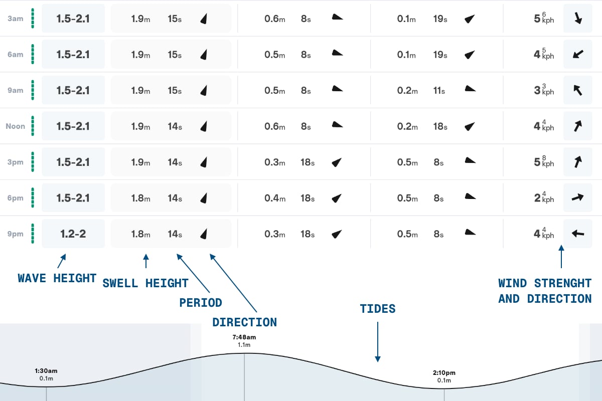
Swell height
Measured in feet or meters, this tells you how big the waves are in deep water. But don’t be fooled! Swell height doesn’t always reflect the breaking wave height at your beach break or reef.
Wave height
This is the estimated height of the actual breaking waves at a specific spot. Wave height is influenced by swell height and period.
Swell direction
The direction from which waves originate and travel toward the shore. For example, an easterly swell comes from the east. It'll hit east coast surf spots. Likewise a northerly swell will hit north facing shores.
Swell period
The time between wave crests in seconds. Measured in seconds. Longer periods (11 seconds or more) pack more wave energy, producing cleaner and more organized sets that travel longer distances across the ocean. Shorter periods (10 seconds or less) produce choppier and more peaky conditions.
Wind
Offshore winds come from the land and blow towards the sea. They shape waves into smooth, glassy lines that are ideal for surfing. Onshore winds, by contrast, blow from the sea towards the land. Onshore waves break unpredictably, making them messy and harder to ride. Light winds are often the best chance for good surf.
Tide
The stage of the tide affects wave shape and when a break works best. Some spots love a high tide push, others break hollow and steep on a draining low. Knowing what tide any wave on the planet works best on requires a combination of first-hand experience and local knowledge sourced the old school way (aka talking with other surfers!).
How to read a surf forecast properly
To get the most out of a surf forecast, you need to look beyond the surface and understand how swell, wind and tide interact with your break.
Don’t just glance at the app or rely on ratings. Breaks are complex. Their response to ocean conditions varies with the season, tides and wind or swell angles.
If you’re surfing a north facing beach, for example, check that the swell direction is coming from the north, northeast or northwest.
Likewise, an offshore wind on north facing shores will blow from the south. This wind direction will clean up the waves, however, a gentle onshore or cross-shore (blowing from the side) can also produce surfable conditions.
Oh... and always adjust your expectations based on your ability. Beginners won't benefit from giant surf with a 14 second period at an exposed beach break, despite what the spot rating might read.
Common mistakes
Many surfers (especially those new to reading forecasts) fall into predictable traps. Here’s what to avoid if you want to build surf knowledge and avoid wasted sessions.
Only trusting star ratings
They’re helpful at a glance, but they don’t reflect local quirks like tidal shifts, sandbars or protected wind pocket along the coastline.
Ignoring wind conditions
A perfect swell means little if a strong onshore wind is wrecking the face of the wave. Gentle onshore or cross-shore, light to moderate offshore or even no wind is usually the best chance for clean surf. Go outside and check for yourself, if possible!
Misunderstanding tides
Knowing your break’s ideal tide is critical. Some waves go completely flat on a full tide, while others only work at low tide.
Focusing only on height, not period
Two swells with the same height can surf very differently depending on period. A 6-foot swell with a 7-second period may feel weak and disorganized, while a 6-foot swell with a 17-second period can produce heavy, hollow surf.
Forgetting about access and safety
Surf reports might look good, but if the road is closed, the paddle-out is brutal or rip currents are tearing through the lineup, the session might not be worth it. Exercise caution... especially if heading out alone or surfing somewhere for the first time.
Quick tips to get better
Surf forecasting is a skill that improves with time, repetition and feedback. Here are some easy ways to sharpen your instincts.
Tip #6: Log every session
Track swell direction, size, wind, tide and how the waves actually looked. Was it clean and glassy or disorganized? This helps you learn how the forecast aligns with the real water conditions.
Tip #5: Compare multiple apps and websites
Don’t expect one app or one set of reviews to give you all the answers. Sites like Surfline and Windy pull from different models. Compare to see what aligns best with your local spot.
Tip #4: Surf with experienced surfers
Whether at reef points or beach breaks, locals often know how to read the ocean better than any forecast. Watch and learn from them.
Tip #3: Talk to others in the lineup
If you’re unsure, ask. Fellow surfers can offer insights about swell behaviour, winds and currents specific to that day or season.
Tip #2: Start with manageable conditions
For beginners, light winds, small swell and sunny days are ideal. Build confidence before tackling heavier or more complex setups.
Tip #1: Review post-session
After your surf, go back and review the forecast. Did the tide, swell or wind match your experience? This will help you build spot-specific accuracy over time.
FAQ
Q: What’s the difference between swell height and wave height at the beach?
Swell height is measured in deep water, where wave energy hasn’t hit the shore yet. Breaking wave height depends on the seafloor, coastline shape and other factors, and can be larger or smaller than the swell.
Q: Is offshore wind always better?
Generally, yes. It holds up the face of the wave and keeps things clean. But extremely strong offshore winds can occasionally make takeoffs harder. Mild to light offshore breezes are ideal.
Q: Can I trust long-range surf forecasts?
Plenty of forecasts are most accurate in the short term. Within 48 hours. Long-range surf forecasts are helpful for planning, but the actual winds and swell predictions will probably shift as the week rolls on. The good news is that as a surfer, refreshing a surf forecast upwards of 20 times per day is totally normal... even encouraged!
Q: Why does the surf sometimes look worse than expected?
Local variables like shape of the coastline, king or neap tides or unexpected weather fronts can cause a session to fall short of expectations. Even the best surf reports can’t perfectly predict every condition. At the end of the day, you never really know until you go!


